/

Enoshima

Chigogafuchi.jpg

江ノ島

Enoshima

Getting Around Enoshima

Most of the Enoshima area can be travelled on foot. It takes around 10 minutes to travel on foot between the two main stations, Katase-Enoshima Station on the Odakyu Enoshima Line, and Enoshima Station on the Enoden. The area near the stations has a major shopping street, beaches and the (新江ノ島水族館, Shin-Enoshima Suizokukan).
Enoshima Island is connected to the mainland via a 10-minute pedestrian bridge, the Enoshima Benten Bridge (江ノ島弁天橋, Enoshima Benten-bashi). Once you hit the island, there’s a single main walking path that goes all the way to the back of the island, passing by the (江の島サムエル・コッキング苑, Enoshima Samueru Kokkingu En) at the peak of the island and ending at (稚児ヶ淵, Chigogafuchi). The route requires an uphill climb and then a downhill climb on the other side, meaning a round-trip would require that you climb up and down the island twice. For those averse to climbing, there’s a paid escalator service, the Escar, that takes you up to the top of the island on one side of the route.
The areas and beaches between Enoshima and (鎌倉) can be explored via the Enoden (around 30 minutes for the entire route) or a 1 hour and 30 minute walk along the beach, which covers the full route to Kamakura.

Modes of Transport

The best way to experience Enoshima

On Foot

The best way to get around the Enoshima area is on foot. Most places are within walking distance of one another, and easily connected via pedestrian walkways.
Do note that the island is not flat. Visitors begin at sea level at the (江の島弁財天仲見世通り), then begin to scale the 46m hill through the (江ノ島神社, Enoshima-jinja) before reaching the top where the (江の島サムエル・コッキング苑, Enoshima Samueru Kokkingu En) is located. They would then proceed to descend back to sea level to reach the (稚児ヶ淵, Chigogafuchi) and the (江の島岩屋, Enoshima Iwaya). The round-trip of course involves climbing back over the hill to get back to the Benzaiten Nakamise Dori.
Climbing upwards to the Samuel Cocking Garden one-way typically takes around 20 minutes on a leisurely hike. In general, the climb shouldn't be too challenging for most people.

An easy ride to the top

Enoshima Escar

The Enoshima Escar is a one-way paid 46m escalator that runs upwards from the base of the (江ノ島神社, Enoshima-jinja) to the (江の島サムエル・コッキング苑, Enoshima Samueru Kokkingu En) at the peak of the island. The Escar, short for "escalator", costs ¥360 and takes around 4 minutes to reach the top rather than 20 minutes by walking.
The Escar is split into three portions, and so visitors can explore the surrounding areas at the two breakpoints in-between. That being said, the entirety of the Enoshima Escar is covered, and one would likely miss to nice views and scenic sights that come from climbing up on foot.

Sailing to the other side

Benten Maru

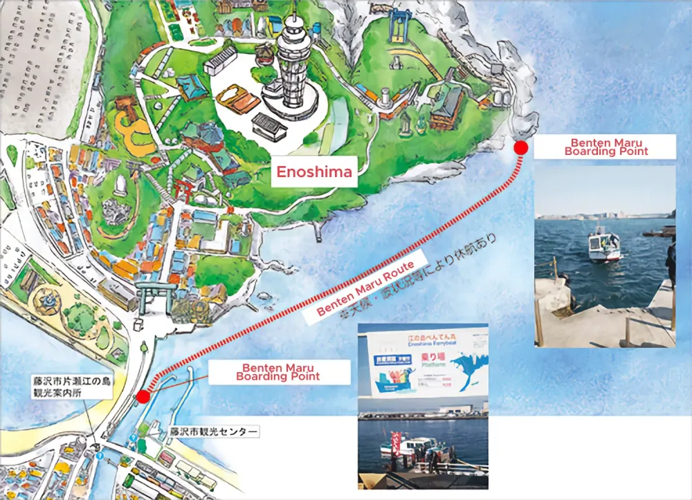
For those who are averse to hiking, there is a ferry service, the Benten Maru, that runs from the middle of the Enoshima Benten Bridge (the bridge that links the mainland to Enoshima) and (稚児ヶ淵, Chigogafuchi) on a 6 minute ride that costs ¥400 one-way.
The ferry runs from 10.15am to 3pm daily, except for December to February where it only runs on weekends. There is no fixed timing for the ferry, and it typically runs when there are passengers around. That being said, when it is crowded, the boat should come at around 10 minute frequency.
The ferry service might also be cancelled in the case of bad sea conditions. You can check the operating status of the boat on the Enoshima Tourism Website's Japanese homepage under "Today's Operating Hours" (本日の営業時間), the right-most column should be for the Benten Maru (べんてん丸). More information about the Benten Maru can also be found at their homepage.

Map

Map of Benten Maru

© 2023 Ki Creative. All Rights Reserved.

Due to changing circumstances, readers are advised to do their own additional research. All information on this site is purely for reference only.

Privacy